As a valued part of the ecosystem of SeaRates IT tools for shipping, Distance & Time is versatile and flexible enough to meet the needs of businesses of all sizes and profiles. Hands-on tools have long been a daily and profitable routine for clients around the world looking to ship their cargo as productively as possible.
Achieving advanced functionality of Distance & Time Version 3.0, our aim of this article is to introduce to you the wider scope of opportunities offered to your business for greater management.
Let's start with improvements to the Distance & Time - new API capabilities.
Latest API enhancements and benefits
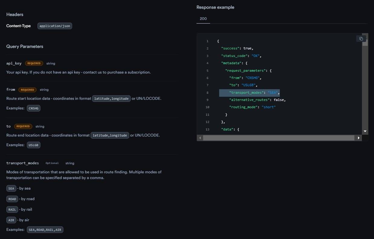
The new Distance & Time API provides users with a new level of granularity in information about our customers' sea, air, road, and rail freight transportation. Improve supply chain efficiency with the route planning API and SeaRates' expanded data on every location in the world.
Accurate determination of locations: To achieve optimized routing and supply chain transparency, the Distance & Time API V. 3.0 includes the ability to specify UN/LOCODE in the departure or arrival field, or both.

Comprehensive coverage for multimodal transportation: A unique approach to calculating distance and transit time through a single convenient tool allows you to specify several types of transport via multi-modal route optimization API. Your requests will take seconds. Just separate the types of transport required for your transportation route with a comma and get it calculated instantly.

Freight auto-routing: Distance & Time API V. 3.0 has improved the logic for determining the most suitable routes for any of your requests. In practice, this means that you don't need to specify any transport types at all, as they will be selected automatically. In case you have individual needs for transport modes, specify which ones your cargo should be transported by. The API will promptly calculate the distance and transit time results based on this information.
Expanded alternative options: Request directly into the shortest path calculation API with travel time to access alternative routes, which saves you time in the planning phase of the entire supply chain.

Complete information at a glance: Users of the advanced API will be able to use the extensive functionality of the time distance calculator with detailed data from shipping lines. Start to reduce logistics planning time with the distance & time API, which provides collected and aggregated insights into statistics for sea routes and advanced details for each location of the request.
How to get your own calculator?
The advanced Distance & Time tool is ready for your CRM/ERP/TMS system as an API integration to achieve streamlined route planning. You can develop your shipping distance calculator using the ready-made functionality and access to the global coverage of calculations and data under your brand! Your customers will get the easiest ways to calculate transit time and distance for their shipments, which will comprehensively complement your logistics services in the pre-sales period.
Technologically, you will not be inferior to any of your competitors because the data in our API is based on unique insights from reliable carrier sources and is constantly being improved. As a result, the entire API with distance & time calculation of routes around the world becomes at least 5 times faster than ever!
Path business operations to improve
Shippers, freight forwarders, carriers, analytical companies, other stakeholders, etc. A comprehensive logistics data integration API with distance & time estimation for inter- and multimodal shipping routes means a lot. SeaRates’ IT solutions ensure API with distance & time data integration into businesses’ flow for the sake of smart and profitable management of production, scheduling, shipping, warehousing, and so on.
No doubt, asking does shipping cost depend on distance, realizing how these miscalculations impact your transportation budget! Thus, you can calculate shipping costs based on distance & time data of alternative, and therefore more profitable, routes than the most popular ones.
Moreover, the route estimation API with distance & time factors considers each individual characteristic necessary for your business. Let SeaRates specialists know about your intention to integrate the Distance & Time API, and we will ensure a smooth integration depending on the specific needs of your business.
Check out the new distance & time calculator documentation on the SeaRates Developer Portal: find a description of the API, information about API endpoints, request parameters with descriptions, a response scheme, and a response example.
Newest improvements for the web version
The web version of the Distance & Time on SeaRates.com tool has also been enhanced under the new version of the API, providing higher-than-ever route accuracy and detailed data for maritime transportation.
The improved functionality shows you how to calculate distance and time for shipping by sea, air, road, and rail. You already have the option to select "Rail" in the "Transportation by" field on the web access of the tool on SeaRates.com:

Distance & Time calculation for rail transportation from Bratislava, SK, to Budapest, HU.
By using a real-time map visualization API with travel time overlay on the web, managing your shipments and timely undertaking significant action became as handy as possible:

Transit time and route distance data with real-time visualization for sea shipping from Houston, US, to Lisboa, PT.

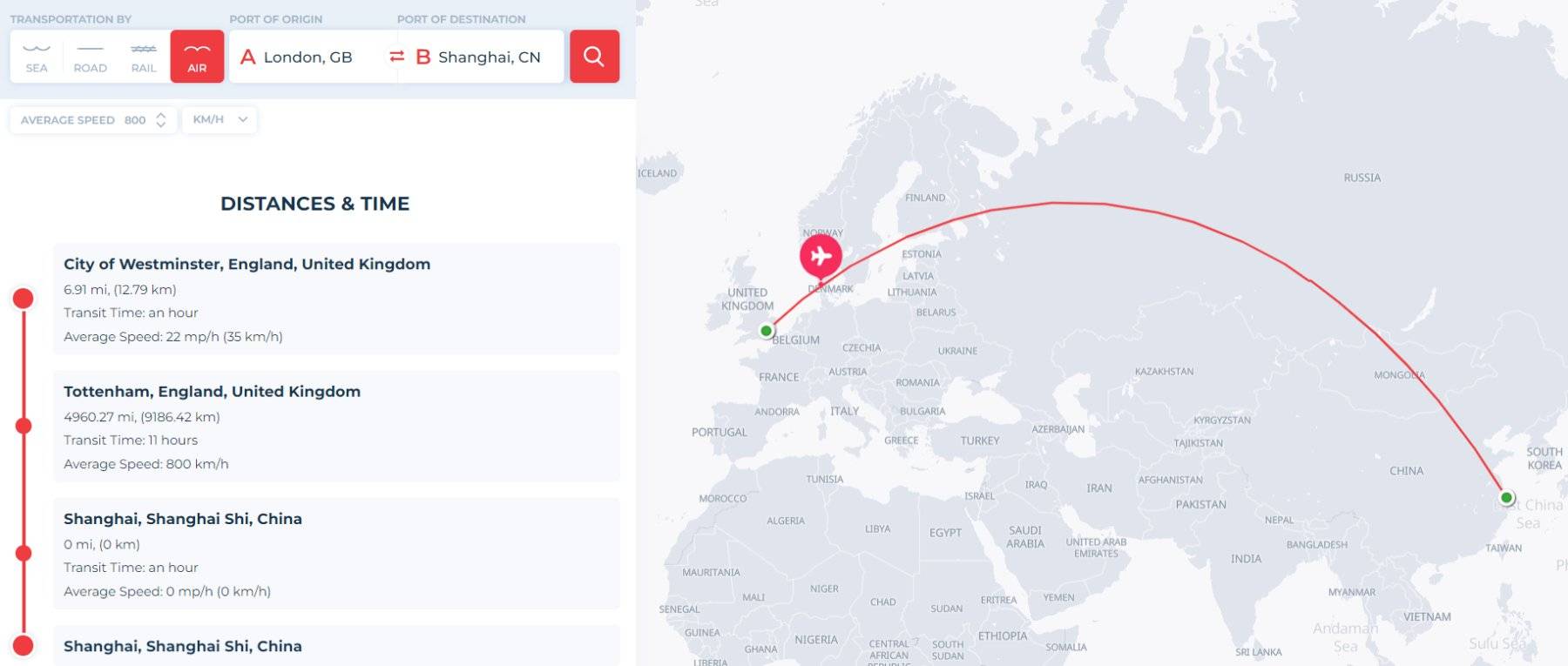
Transit time and route distance data with real-time visualization for air shipping from London, GB, to Shanghai, CN.
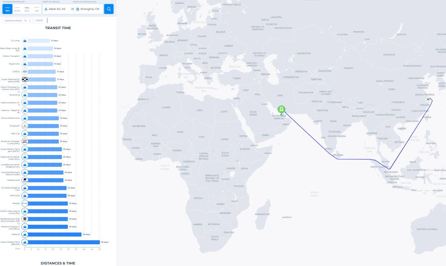
When you know how to find time and distance, discover a wider scope of historical transit data from world shipping lines and an interactive distance time graph:

Historical transit data from global shipping lines for sea transportation from Jebel Ali, AE, to Shanghai, CN, provided by SeaRates Distance & Time.
Finally, to ensure greater customization of the calculation of transit time and distance, check out the updated default ‘Average Speed’ parameter. You can customize this indicator for each mode of transportation, which will provide more accurate calculations for individual needs:

Customized ‘Average Speed’ parameter to estimate transit time for road transportation from Prague, CZ, to Bilbao, ES.
With just a couple of clicks, you can get a calculation displaying key information about transit times and route distances, which automates supply chain management fully. The latest data from global logistics providers is also driving the industry to implement valuable insights into the day-to-day logistics operations of businesses around the world. Accurate real-time calculation of cargo transportation routes by any mode of transport complements the logistics and trading operations of all stakeholders.
Conclusion
Following the online transit time & route distance calculation, as well as discussing how to find distance with velocity and time, we got a closer look at the new improvements to the Distance & Time tool. For an understanding of the broader possibilities, we highlighted the capabilities of the distance & time data API for logistics analysis and planning.
We are dedicated to fulfilling your needs in international logistics and freight forwarding with the highest possible results. You are always welcome to contact the SeaRates team at [email protected] for customized logistics services.

